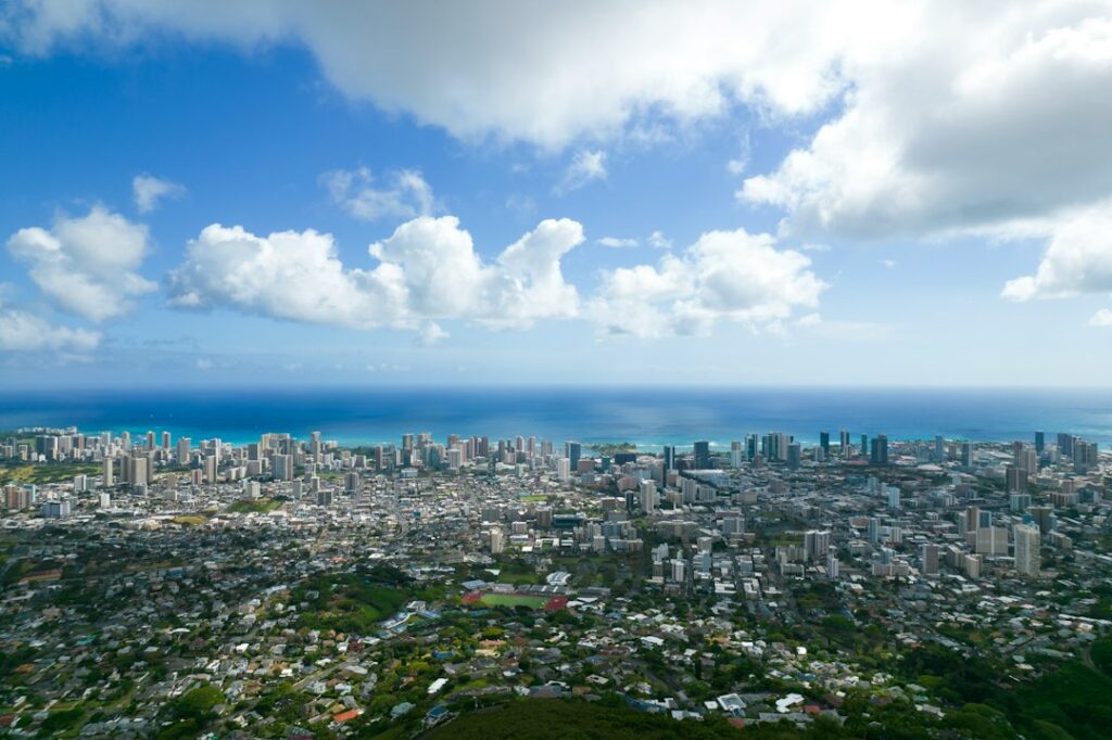
Above Manoa Valley, a narrow 10-mile ribbon of asphalt threads through eucalyptus and bamboo, gaining nearly 2,000 feet of elevation before dropping back into the western edge of Makiki. The road carries two names — Tantalus Drive on the western climb, Round Top Drive on the eastern descent — but the two connect into a single continuous loop above Honolulu. Locals, cyclists, and evening view-seekers treat it as one route.
The centerpiece is Puu Ualakaa State Wayside, a small hilltop park roughly halfway around the loop. From its western railing, the panorama sweeps from Diamond Head on the far left to Pearl Harbor on the right, with downtown towers, Waikiki high-rises, and Honolulu International Airport arrayed across the coastal plain below. Sunset draws steady traffic to the park’s 20-odd parking stalls, and the gate closes on a schedule that catches unprepared visitors off guard.
This article documents the Tantalus Drive Oahu scenic loop from a research angle — road geometry, direction of travel, seasonal gate hours, rental-car fit, and how the drive slots into a broader Honolulu itinerary. It also flags the practical friction points relocating households encounter when scouting Manoa-adjacent neighborhoods, where the loop road doubles as a commuter shortcut for a handful of ridge homes.
Where the Tantalus–Round Top Loop Sits Above Honolulu
The loop sits directly above Manoa and Makiki, two urban valleys that fan north from downtown Honolulu into the Koolau foothills. From Waikiki, the western entrance (Makiki Street feeding Round Top Drive) is roughly 3 miles by surface streets; the eastern approach via Manoa Road and East Manoa Road is a similar distance. Drivers usually reach either endpoint in under 15 minutes outside rush hour.
Elevation climbs quickly. The road tops out near 1,600 feet on the Tantalus side and drops through switchbacks back toward Punahou. Puu Ualakaa Wayside itself sits at roughly 1,048 feet — lower than the road’s crest, but positioned on a spur that clears the tree line and opens the southern view corridor. A few dozen ridgeline homes cling to steep parcels along the way.
What the Loop Actually Connects
Tantalus Drive and Round Top Drive share signage and mile-post numbering as one continuous road, even though the naming shifts near the top of the ridge. State highway records list them as connected forest-reserve routes rather than a numbered state highway. The Hawaii Department of Transportation categorizes both as county-maintained scenic corridors within the City and County of Honolulu.
The loop borders three named neighborhoods — Makiki Heights on the south, Tantalus on the ridge itself, and Manoa/Woodlawn on the eastern flank. Between them lies the Makiki Forest Reserve, roughly 2,000 acres of watershed and reforestation planting managed by the state. Trail access points from the loop road feed into the Makiki Valley trail network below.
Counterclockwise vs Clockwise: Choosing the Driving Direction
Either direction covers the same asphalt, but the two orientations feel different from the driver’s seat. Counterclockwise — up Round Top Drive first, over the ridge, down Tantalus — puts the tighter, more consequential switchbacks on the descent, when a driver is already warmed up to the road’s rhythm. Clockwise, up Tantalus first, front-loads the hardest hairpins and delivers the Puu Ualakaa Wayside as a mid-loop reward.
Most visitors default to counterclockwise because the entrance from Round Top Drive is easier to find from Waikiki via Wilder Avenue and Makiki Street. The parking lot at Puu Ualakaa sits on the driver’s right about 4 miles into the loop that way, allowing a straightforward pull-in without crossing oncoming traffic. Sunset viewers particularly favor this direction.
Clockwise has one practical advantage — it exits into upper Manoa near the University of Hawaii, which pairs well with a Manoa Falls trailhead stop. Drivers heading to the Manoa Falls rainforest trail after the loop often prefer this order because it drops them within a mile of the trailhead without doubling back.
| Aspect | Counterclockwise (Round Top up) | Clockwise (Tantalus up) |
|---|---|---|
| Wayside entry | Right turn, straightforward | Left turn across traffic |
| Switchback difficulty first | Wider curves early | Tighter hairpins early |
| Exit neighborhood | Makiki/downtown side | Manoa/UH side |
| Sunset viewing fit | Preferred by most drivers | Works if arriving early |
| Typical loop time | 35–45 minutes | 40–50 minutes |
Whichever direction a driver picks, the loop remains a slow route. Speed limits post at 15–25 mph, and posted advisory signs on the sharpest turns drop to 10 mph. Adding a Puu Ualakaa stop of 20–30 minutes brings the round trip to about an hour from valley floor to valley floor.
Puu Ualakaa State Wayside: The Central Overlook
Puu Ualakaa translates roughly as “rolling sweet potato hill,” a reference to nineteenth-century agricultural terracing on the slope. The wayside is a compact state park with a paved loop road, a small central lawn, two overlook railings, and picnic tables scattered under ironwood and monkeypod trees. The main viewpoint faces roughly southwest across the Honolulu coastal plain.
What the Panorama Includes
From left to right at the primary railing, the eye picks up Diamond Head crater’s 762-foot rim, the Waikiki high-rise cluster, Ala Moana and Kakaako, downtown Honolulu, the Aloha Tower waterfront, Sand Island, Honolulu International Airport runways, and — on a clear day — the entrance channel to Pearl Harbor roughly 8 miles west. Behind and above, the Koolau ridge frames the northern horizon.
Clear-air days deliver the widest panorama, but trade-wind haze and southern-flow vog from Big Island volcanic activity can shrink visibility to a few miles. The Hawaii Department of Health publishes air quality readings that correlate closely with what visitors see from the overlook. October through April typically brings the crispest sightlines.
Wayside Gate Hours and Rules
The City and County of Honolulu and the state parks division jointly manage access. Gates open at 7:00 a.m. year-round. Closing times shift with sunset: roughly 6:45 p.m. from November through March, and roughly 7:45 p.m. from April through October. Staff physically lock the entrance gate at the posted time, trapping any vehicle still inside overnight until morning reopening.
| Season | Approximate open | Approximate close | Peak sunset window |
|---|---|---|---|
| November–February | 7:00 a.m. | 6:45 p.m. | 5:50–6:10 p.m. |
| March | 7:00 a.m. | 7:15 p.m. | 6:30–6:45 p.m. |
| April–May | 7:00 a.m. | 7:45 p.m. | 6:50–7:10 p.m. |
| June–July | 7:00 a.m. | 7:45 p.m. | 7:15–7:20 p.m. |
| August–September | 7:00 a.m. | 7:45 p.m. | 6:45–7:15 p.m. |
| October | 7:00 a.m. | 7:15 p.m. | 6:15–6:30 p.m. |
Rules posted at the entrance prohibit alcohol, drone flights without permit, and open fires. Dogs are permitted on-leash. No overnight parking, camping, or vehicle sleeping is allowed. Rangers occasionally patrol just before closing to shepherd stragglers toward the exit gate.
The Road Itself: Switchbacks, Grade, and Vehicle Restrictions
The full loop covers roughly 10 miles of asphalt with an aggregate elevation gain of about 1,600 feet from the Round Top entrance to the ridge crest. Grades hit 12 percent on some Tantalus-side sections. The pavement is patched frequently but retains dips, root heaves, and shoulder washouts, particularly on the western descent through denser rainforest cover.
Cyclists and runners share the road, often without shoulder space to buffer them. Drivers should assume a two-wheeler or a jogger sits around every blind curve and slow accordingly. Descending motorists occasionally over-brake and lock wheels on damp pavement — trailing distance matters more here than on ordinary roads.
Why RVs, Trailers, and Buses Should Not Attempt It
Signage near both entrances warns off vehicles over 25 feet or with trailers. The switchback radius on several turns runs under 30 feet, tighter than the turning circle of standard Class-C motorhomes. Even large SUVs with roof cargo boxes report scraping overhanging branches on the Tantalus side. Tour buses reroute to lower-elevation viewpoints or bypass the ridge entirely.
Fuel-hauling trucks, delivery box trucks over 20 feet, and cargo vans with high sidewalls face similar problems. A driver committed to a large vehicle should reverse plans and choose the Oahu H-3 Freeway windward drive instead — that route accommodates full-size vehicles with wide, banked curves and no hairpin geometry.
Cyclist and Runner Presence
The loop is a well-known local training climb. Serious cyclists tackle the Round Top ascent as a repeatable interval workout, with elevation gain per mile ranging from 200 to 400 feet on the steeper stretches. Runners use the shoulder for hill repeats. Peak recreation traffic runs early morning (5:30–7:30 a.m.) and again at dusk (5:00–6:30 p.m.).
Makiki Forest Reserve Pullouts and Trailheads
The Makiki Forest Reserve wraps most of the loop’s interior. Established under state watershed protection statutes, the reserve preserves reforestation experiments dating to the 1930s Civilian Conservation Corps era. Small dirt pullouts and gravel shoulders along the road serve as informal trailheads for hikes that drop back into Makiki Valley or climb toward the Koolau ridge.
Named Trailheads Along the Loop
- Manoa Cliff Trail — northeast side of the loop, 3.4 miles round trip
- Puu Ohia (Mount Tantalus) summit trail — 2.0 miles to a 2,013-foot high point
- Kanealole Trail — connects downward to Makiki Nature Center via 0.7 miles
- Makiki Valley Loop — 2.5-mile forest loop accessible from mid-elevation
- Nahuina Trail — 0.7-mile descent to Makiki Valley floor
Parking at these trailheads is limited to whatever the gravel shoulder allows — typically two to four cars per pullout. The Makiki Nature Center, at the lower end of the network on Makiki Heights Drive, offers dedicated trailhead parking during daylight hours. Hikers combining Tantalus driving with foot exploration usually start from the Nature Center.
Parking Etiquette at Pullouts
Roadside pullouts are narrow and shared with residents who must access their driveways. Blocking any private driveway triggers a tow call quickly. Two-wheel-drive vehicles risk shoulder collapse on the softer dirt edges, especially after heavy rain. Local convention: pull as far right as safely possible, four-way flashers on, and never park within 30 feet of a blind curve.
Sunset Parking Capacity and Timing
Puu Ualakaa State Wayside offers roughly 20 marked parking stalls plus a small overflow loop that can accommodate perhaps 8 more vehicles if drivers self-organize. Sunset demand routinely exceeds supply on Friday and Saturday evenings between April and September. By 45 minutes before sunset, the primary lot is typically full, and by 20 minutes before sunset, the overflow saturates as well.
Arrival Timing Recommendations
Research on gate cycles and observed occupancy patterns suggests the arrival windows below for reliable parking. Weekday visits enjoy substantially more availability than weekend visits year-round.
| Day and Season | Recommended arrival before sunset | Backup plan if full |
|---|---|---|
| Weekday, winter (Nov–Mar) | 25 minutes | Wait or use pullout |
| Weekday, summer (Jun–Aug) | 40 minutes | Wait or use pullout |
| Friday/Saturday, winter | 50 minutes | Round Top pullout view |
| Friday/Saturday, summer | 75 minutes | Round Top pullout view |
| Sunday, all year | 45 minutes | Circle loop and retry |
Overflow is not officially designated. Some visitors park along the wayside’s exit lane, which staff tolerate on quiet nights and ticket on busy ones. The safest fallback is a Round Top Drive pullout roughly 0.3 miles before the wayside entrance, which offers a similar though partially framed view.
What Happens After the Gate Closes
Once the gate is locked, no vehicle can exit until morning reopening at 7:00 a.m. Enforcement is consistent — occasional media coverage in the Honolulu Star-Advertiser documents locked-in visitors calling police for gate access, generally with limited success. Watches, phone alarms, and a printed close-time reminder taped to the dashboard all work as prevention.
Rental Car Fit and Insurance Considerations
Most rental sedans, compact SUVs, and midsize crossovers handle Tantalus Drive without difficulty. Vehicles with poor low-speed steering geometry — some full-size pickup trucks, extended-cab configurations, and stretch SUVs — find the tightest hairpins awkward but not impossible. Manual-transmission rentals benefit from lower gears on the descent to avoid brake overheating.
| Vehicle class | Suitability | Notes |
|---|---|---|
| Compact sedan (Corolla, Civic) | Excellent | Best turning radius, adequate power |
| Midsize sedan (Camry, Accord) | Excellent | Comfortable, no issues |
| Compact SUV (RAV4, CR-V) | Very good | Slight body lean in hairpins |
| Midsize SUV (Highlander, Pilot) | Good | Manageable, use lower gear on descent |
| Full-size SUV (Suburban, Expedition) | Marginal | Wide turns require careful line |
| Convertible (Mustang, Wrangler) | Very good | Popular for open-air sunset viewing |
| Pickup with 6-ft bed | Marginal | Tight on switchbacks |
| Camper van or Class C RV | Prohibited | Over length and radius limits |
Insurance and Off-Road Coverage
Standard rental agreements generally cover paved public roads, and Tantalus Drive qualifies. Damage caused by fallen branches, tree debris after storms, or side-mirror scrapes on overgrown foliage is not usually treated as off-road use. Drivers who purchased a collision damage waiver at pickup are covered for such incidents; those relying on credit card coverage should verify their card’s specific exclusions.
Fuel and Range Planning
No gas stations exist on the loop itself. The nearest 24-hour stations sit on King Street (2 miles south) and Beretania Street (2.5 miles south). At Hawaii’s average regular unleaded price — often 20 to 40 cents above the national mean per the U.S. Energy Information Administration weekly report — the full 10-mile loop consumes roughly $1.50–$2.00 of gasoline in a compact car.
Combining Tantalus With Other Honolulu Attractions
The loop pairs naturally with a Manoa morning and a Waikiki dinner. Under two hours of driving separates it from most eastern Oahu attractions, and the elevation change makes it a distinctive contrast to sea-level itineraries. Households scouting neighborhoods often combine a Tantalus drive with an open-house tour in Manoa or Makiki Heights to gauge commute realities.
Half-Day Itinerary
A common half-day sequence begins with the Diamond Head crater summit ascent at sunrise (5:30–7:30 a.m.), coffee in Kaimuki or Kapahulu, then the Tantalus loop in late afternoon light with a sunset finish at Puu Ualakaa Wayside. Total driving distance stays under 25 miles across the whole day.
Full-Day Itinerary
A full day expands with a morning Manoa Falls walk, midday lunch on University Avenue, an afternoon Tantalus loop, and a sunset return to Waikiki. Alternative combinations pair Tantalus with the Koko Head railway climb for two elevation payoffs in one day — one at 1,048 rungs of vertical stairs, one near 1,048 feet of ridge overlook.
Contrasting Sunrise Alternatives
For visitors more oriented toward sunrise than sunset, the Lanikai Pillbox windward sunrise across the Koolau ridge delivers an east-facing counterpart to Tantalus’s west-facing evening light. Doing both within a 24-hour period gives a full-compass sense of Oahu’s ridge topography. Timing them requires a very early rise and a late sunset return.
The Loop’s Origins and Modern Use
Tantalus Drive was cut through the ridge in the early twentieth century as part of Honolulu’s watershed reforestation and recreation planning. Round Top Drive followed shortly after to close the loop. Names reflected classical education — Tantalus after the mythological Greek figure — and topography (Round Top after the summit’s shape). By the 1930s, Civilian Conservation Corps crews had installed the ironwood and eucalyptus that still shade much of the road.
Modern use divides between residents, commuters cutting between Manoa and Makiki, recreational cyclists, tourists driving the loop, and evening view-seekers. The Hawaii Tourism Authority lists the drive among Oahu’s signature scenic routes. Weekend traffic peaks between 4:30 and 7:00 p.m., correlating tightly with sunset arrival patterns.
Local Cultural Significance
Puu Ualakaa carried agricultural and spiritual importance in the pre-contact Hawaiian era. Sweet potato terraces on the slope fed communities in Manoa Valley below, and the hill’s silhouette served as a navigational reference from the harbor. Contemporary interpretive signage at the wayside references this history briefly. Deeper context is available through Bishop Museum resources and University of Hawaii publications on Manoa history.
Safety, Weather, and Seasonal Considerations
The Manoa side of the Koolau range averages 150+ inches of rainfall annually — one of the wettest urban corridors in the United States. Tantalus sits high enough on the ridge to catch orographic showers year-round, though the leeward Makiki side stays drier. Fog and low cloud can shroud the wayside without warning, particularly in winter months and early morning hours.
Wet pavement dramatically extends braking distance on the descent. Storm-toppled branches occasionally block short segments of road; the City typically clears them within 24 hours per Honolulu Civil Beat reporting on urban forestry response times. Drivers encountering fallen debris should not attempt to squeeze past — reverse to a pullout and reroute.
What to Bring
- Light jacket — temperatures at the wayside run 5–8°F cooler than sea level
- Water bottle — no drinking fountains on the loop
- Bug spray — mosquitoes active at dusk in the wetter sections
- Camera or phone tripod — long exposure preserves twilight color gradients
- Headlamp — useful for walking back to the car after gate warning
- Cash or card — nearest amenities sit 2 miles downhill
Vog and Air Quality
Volcanic emissions from Big Island Kilauea eruption cycles occasionally drift up the island chain on southerly Kona winds and settle over Honolulu. On heavy vog days, the panoramic view compresses from 15+ miles of visibility to under 3 miles, and haze reduces color saturation at sunset. Historical vog events documented by local news outlets tend to cluster in fall and winter months.
What Relocating Households Learn From the Drive
The loop road passes several dozen ridge-perched homes valued in the multi-million-dollar range as of recent Honolulu county assessments. Owners tolerate narrow-road access, occasional gate-driven traffic, and 30-minute commutes to downtown Honolulu in exchange for privacy and unbroken views. For anyone weighing moving to Oahu versus a neighbor island, the drive illustrates why ridge micro-neighborhoods carry premium price tags.
Lower-elevation neighborhoods along the loop’s endpoints — Makiki, Manoa, and Punahou — offer more attainable rents and proximity to the University of Hawaii, restaurants, and grocery stores. Transit access is imperfect but functional: TheBus routes 4 and 6 serve the Makiki base of the loop, though no bus climbs Tantalus itself. Details on transit gaps are covered in the site’s guide on getting around Oahu without a car.
Water utility, road maintenance, and slide risk factor into any purchase decision on the ridge. Storm-cycle landslides have closed short segments in past decades. Prospective buyers should request geotechnical review and check for slope-stability easements before signing. Insurance carriers price hillside properties above valley averages, sometimes materially so.
Frequently asked questions
Is Tantalus Drive open at night?
The road itself remains open 24 hours as a public street, but the Puu Ualakaa State Wayside overlook closes at sunset — roughly 6:45 p.m. in winter and 7:45 p.m. in summer. Drivers can circle the loop after dark, though the road offers no lighting and the payoff overlook is inaccessible. Local residents use the road for late commutes without incident.
How long does the Tantalus loop take to drive?
A non-stop drive of the full 10-mile loop takes about 35 to 45 minutes depending on traffic and direction. Adding a 20 to 30-minute stop at Puu Ualakaa Wayside pushes total time to approximately one hour. Cyclists complete the climb in 45 to 75 minutes, while descent takes about 15 minutes with cautious braking on the switchbacks.
Which direction offers better views?
Counterclockwise (Round Top up, Tantalus down) is generally preferred because the Puu Ualakaa Wayside entrance sits on the driver’s right, allowing a simple pull-in. The clockwise direction works well when pairing the drive with a Manoa Falls trailhead visit afterward. Views from the wayside itself are identical regardless of driving direction — only the road experience differs meaningfully.
Are there restrooms at Puu Ualakaa Wayside?
Yes, the wayside includes basic restroom facilities near the central lawn and picnic area. Facilities are typically maintained daily during standard operating hours and lock when the entrance gate closes at sunset. No drinking fountains are available, so visitors should bring their own water. The nearest gas-station restrooms sit approximately 2 miles downhill on Wilder Avenue or King Street.
Can rental cars go up Tantalus Drive?
Yes — standard rental agreements from Honolulu airport agencies cover Tantalus Drive as a paved public roadway. Sedans, compact SUVs, and convertibles handle the loop without incident. Full-size trucks and camper vans are discouraged by posted signage due to length and turning-radius limits. Drivers should confirm any specific exclusions with their rental contract, particularly regarding overhanging-branch damage or shoulder scrapes.
Is the road safe to drive after rain?
Wet pavement significantly extends braking distance on the Tantalus-side descent, and fallen branches or leaf debris occasionally block short segments after storms. Drivers should reduce speed by roughly one-third, maintain wider following distance, and use lower gears rather than continuous brake pressure. Serious storm cycles can trigger temporary road closures announced through official Honolulu channels.
Where should visitors park if the wayside lot is full?
The most reliable fallback is a wide pullout on Round Top Drive roughly 0.3 miles before the wayside entrance, which offers a partially framed view of the same panorama. A second option is circling the loop and re-trying entry 15 to 20 minutes later. Never park along private driveways — tow response is quick, and towing fees typically exceed $250.
Can visitors bike the Tantalus loop safely?
Yes, but with caveats — the loop is a popular cyclist training route with steep grades and no dedicated bike lane. Riders share the road with cars on 15 to 25 mph switchbacks. Descending riders should use both brakes moderately to avoid overheating rims, and reflective gear is essential in early morning or dusk hours. Weekday mornings before 7:30 a.m. offer the safest cycling window.


