The Lanikai Pillbox hike — technically the Kaiwa Ridge Trail — climbs 1.7 miles round trip to two WWII-era concrete bunkers with what many rank as the best sunrise view on Oahu. The route is short, the payoff is enormous, and the ticket systems that gate Diamond Head or Haleakala do not apply here. That combination has made Kaiwa Ridge one of the most crowded free hikes in Hawaii.
It has also made the surrounding neighborhood one of the most contested. In 2020, the City and County of Honolulu enacted a residential parking ban along Ka’elepulu Drive after years of resident complaints about pre-dawn traffic, blocked driveways, trash, and human waste in yards. Honolulu Police Department now patrols the block, and tickets are routine. Households researching a windward Oahu move should understand the access rules before showing up at 4:30 a.m. with a rental car.
The sections below cover the trail’s specifications, the 2020 parking rules that reshaped access, where visitors legally leave a vehicle now, sunrise timing math, rain-slick ridge hazards, the resident etiquette that keeps the trail open at all, and how the experience compares to ticketed sunrise hikes elsewhere in Hawaii.
The trail: 1.7 miles, 550 feet, two concrete bunkers
The Kaiwa Ridge Trail leaves a residential block in Lanikai and climbs a spine of red clay and ironwood pine to the first pillbox at about 0.5 miles. A second pillbox sits another 0.4 miles beyond, at roughly 0.9 miles from the trailhead. Total round-trip distance is about 1.7 miles with 500 to 550 feet of elevation gain.
Distance, elevation, and time budget
Fit hikers reach the first pillbox in 20 to 25 minutes. A slower pace, or a group with children, should budget 40 minutes to the same point. The ridge is fully exposed once the sun clears the horizon, so most sunrise seekers linger 15 to 30 minutes at the top and descend before temperatures climb past 80°F. A reasonable full round-trip block is 90 minutes to two hours.
The pillboxes themselves
The two bunkers are relics from 1943, part of an observation post network the U.S. Army built after the December 1941 attack on Oahu. Each concrete box measures roughly 6 feet by 8 feet inside, with narrow sight slits facing seaward. Both interiors are heavily graffitied. Neither is engineered for gatherings — the roofs crack under weight, and the edges drop off with no railing.
Sightlines and the Mokulua Islands
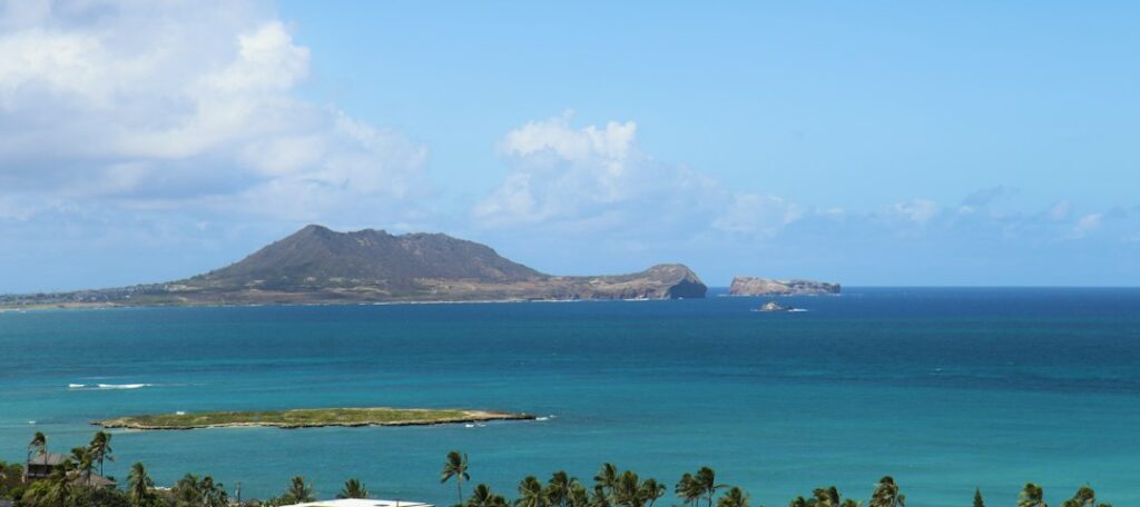
The reason the trail is famous: it stares directly at the Mokulua Islands (Moku Nui and Moku Iki), the twin bird-sanctuary rocks a half mile offshore from Lanikai Beach. Sunrise breaks over the horizon behind them, backlighting the silhouettes and the reef break. Kailua Bay curves to the north, and the Ko’olau range rises to the west, catching alpenglow a few minutes after first light.
The Hawaiian name and cultural note
The trail’s proper Hawaiian name is Ka Iwa, referring to the frigatebird — the seabird whose long silhouette matches the ridgeline. “Pillbox” is a visitor-era nickname tied to the military use. Both names are in circulation; state trail maps use Kaiwa Ridge. The Hawaii Tourism Authority’s official visitor guidance avoids the pillbox nickname when describing the site formally.
The 2020 parking ban on Ka’elepulu Drive
For years, hikers parked bumper-to-bumper along Ka’elepulu Drive, the narrow residential street that leads to the unmarked trailhead. Complaints from Lanikai households — blocked driveways, trash in yards, cars idling at 4 a.m., and headlights sweeping bedroom windows — built through the late 2010s. In 2020, the City and County of Honolulu installed “No Parking Any Time” signage along both sides of Ka’elepulu Drive within roughly a quarter mile of the trail.
How HPD enforces the ban
HPD enforces the signage with patrols weighted to sunrise and weekend traffic. Citations run in the range of $35 to $200 depending on the specific violation, and tow risk is real when a vehicle blocks a driveway, hydrant, or fire lane. The department has not published patrol counts, but Star-Advertiser coverage and longtime residents describe frequent morning sweeps in high season.
What the ban did and did not do
The ban did not close the trail. Kaiwa Ridge itself remains public state land, and the trailhead is a marked easement between two homes. What changed is that arriving by private vehicle now requires parking elsewhere — a fact that catches many first-time visitors who assumed the nearest curb was fair game. The absence of a shuttle system leaves logistics on the visitor.
Why the community pressed for it
The complaints that drove the ban were specific and repeated. Households on Ka’elepulu Drive documented human waste in landscaping, group photos in private yards, coffee cups tossed in gardens, and idling cars playing music at 4:30 a.m. Civil Beat’s reporting traced the multi-year community organizing that produced the 2020 signage decision. The ban was the compromise chosen over an outright trailhead closure.
Where to legally park in 2026
Three practical options exist, all requiring a walk-in to the trailhead. None are perfect. The best choice depends on group size, arrival time, and willingness to walk in the dark.
| Parking spot | Distance to trailhead | Walk time | Cost |
|---|---|---|---|
| Kailua Beach Park lot | 1.2 miles | 22–28 minutes | Free |
| Mid-Pacific Country Club overflow* | 0.2 miles | 4–5 minutes | Varies; private property |
| Kailua Town municipal lots | 1.6 miles | 30–35 minutes | Free or metered |
| Rideshare drop at Ka’elepulu / Mokulua | 0 miles | 0 minutes | $12–$25 from Kailua |
*Mid-Pacific Country Club is private property and does not formally host hiker parking. Some overflow use has been tolerated at various times but is not guaranteed. Check current signage on arrival and never park in member-designated stalls.
Kailua Beach Park: the default
The Kailua Beach Park lot at 526 Kawailoa Road is the most reliable public option. It opens at 5 a.m. daily and parking is free. The walk to the trailhead runs about 1.2 miles along residential sidewalks, taking 22 to 28 minutes at a normal pace. Restrooms and drinking fountains are available at the park before the walk in — the last legal stop before the ridge.
Rideshare and TheBus
Uber and Lyft will drop passengers at the trailhead corner, and this is the lowest-friction option for a party of one or two. Fares from central Kailua run $12 to $18; from Waikiki, budget $45 to $70 depending on surge. TheBus Route 67 serves Kailua Town from downtown Honolulu, with a further 25-minute walk from the last stop.
Why not to circle the block hoping for a spot
Circling Ka’elepulu Drive or the immediately adjacent streets is a common first-visit reflex, but the signage is unambiguous and enforcement is active. A 3 a.m. arrival does not exempt the vehicle from citation. Households who intend to hike Kaiwa Ridge repeatedly build the parking walk into the routine, treating Kailua Beach Park as the effective start of the trail.
Sunrise math: when to leave and how early to arrive
The 45-minute-before-sunrise arrival guidance is not padding. It accounts for the walk from a legal parking spot, the climb itself, and the fact that the best photographic light is in the 10 to 20 minutes before the sun clears the horizon — not after.
| Month | Approx. sunrise (Oahu) | Recommended trailhead arrival | Best light window |
|---|---|---|---|
| January | 7:11 a.m. | 6:00 a.m. | 6:45–7:15 a.m. |
| March | 6:35 a.m. | 5:25 a.m. | 6:15–6:40 a.m. |
| June | 5:49 a.m. | 4:40 a.m. | 5:30–5:55 a.m. |
| September | 6:15 a.m. | 5:05 a.m. | 5:55–6:20 a.m. |
| December | 7:00 a.m. | 5:50 a.m. | 6:40–7:05 a.m. |
Civil twilight matters more than sunrise
Civil twilight — when the sun sits 6 degrees below the horizon and the sky glows soft pink — begins roughly 25 minutes before sunrise on Oahu. That is when the Mokulua Islands are backlit but not blown out, and when the trail is bright enough to descend without a headlamp. Photographers aiming for the postcard shot target twilight rather than the sun disc itself.
Headlamps on the way up
The climb starts before civil twilight in most months, so a 100-lumen headlamp is standard kit. Phone flashlights are usable but drain battery fast and light only the ground directly in front of the foot. Two headlamps in a group let the front and back walker share the load and reduce the chance of a fall on the initial steep pitch.
The trade-off between sunrise and sunset
Sunset from Kaiwa Ridge is technically legal but rarely worthwhile. The sun sets behind the Ko’olau ridge to the west, meaning the pillboxes see alpenglow rather than the sun disc, and hikers must descend the clay in fading light. Sunrise remains the dominant use case, and morning weather on windward Oahu tends toward clearer skies than afternoons.
Rain-slick red clay and cliff exposure
Kaiwa Ridge is not a technical climb, but it is genuinely dangerous when wet. The trail surface is compact red clay over volcanic tuff — the same substance that makes Diamond Head’s outer slopes slippery — and windward Oahu averages more than 40 inches of rain per year, concentrated in November through March.
Why the mud is so slick
The clay’s iron oxide content produces a greasy film on the surface when wet. Even after a passing shower, the top layer stays slippery for one to two hours. Approach shoes and trail runners with lug depth over 4 mm grip acceptably. Flat-soled sneakers, sandals, and dress shoes appear consistently in trailhead rescue accounts. Water resistance in the shoe matters less than tread pattern.
Exposed sections and the false summit
Between the first and second pillboxes, the ridge narrows to roughly 3 to 4 feet in spots, with drop-offs of 30 to 60 feet on either side. There are no fixed ropes or handrails. In dry conditions, most fit hikers handle it easily; in the wet, this is where accidents happen. Turning around at the first pillbox is a legitimate call in bad weather.
Honolulu Fire Department rescues
Kaiwa Ridge and the nearby Lanikai ridgelines generate a steady trickle of Honolulu Fire Department helicopter rescues each year, most involving falls on the wet clay descent. A rescue costs the individual nothing directly under current policy, but it consumes crew hours that are prioritized on the windward side during storm response. Hawaii News Now has covered recent incidents in detail.
Weather windows and when to bail
Windward Oahu weather runs a maritime pattern: passing showers driven by trade winds from the northeast, often followed by clearing skies within an hour. A morning showing 100% probability on the forecast often means one wet 45-minute window, not sustained rain. If the trailhead is wet on arrival, waiting 30 to 60 minutes for the surface to firm up is often the safer plan.
Residential etiquette that keeps access alive
Lanikai residents have twice asked the city to close the trailhead outright. The 2020 parking ban was a compromise. Continued access depends on visitor behavior in the residential block leading to the trail, and HPD enforces the etiquette informally through warnings before it becomes formal through citations.
The pre-dawn quiet-hour standard
- Voices at conversational volume, not projected across the street.
- Vehicle doors closed gently — no slamming at 4 a.m.
- No music from portable speakers on the walk-in or on the ridge.
- Headlights dipped when passing houses, especially near driveways.
- Dog barking is a common resident complaint; leash and quiet the dog.
The trash and bathroom problem
There are no restrooms at the trailhead or on the ridge. The nearest facilities are at Kailua Beach Park. Sunrise crowds have historically left tissues, coffee cups, and worse in nearby yards, and this is the single loudest resident complaint driving political pressure to close access. Pack out everything — even organic peels — and use the beach park before walking up.
Drones, tripods, and other flashpoints
Drone use over residential Lanikai is restricted under FAA and City rules, and complaints escalate fast when a drone wakes a household at 5 a.m. Large tripods on the ridge crowd an already narrow trail. The etiquette baseline is: minimize footprint, keep noise down, and defer to residents and other hikers on the ridge.
Group size and shared space
Photography workshops, wedding parties, and influencer shoots have all appeared on the ridge in numbers that stress the narrow terrain. There is no formal group size limit, but functionally, six people is a comfortable ceiling; ten or more begins to crowd the pillbox roof and the trail. Larger groups should split up on ascent and cluster only briefly at the viewpoint.
What to bring, wear, and skip
The essential kit
- Trail runners or approach shoes with lug depth over 4 mm.
- Headlamp with at least 100 lumens and fresh batteries.
- 1 liter of water per person, more in summer.
- Light rain shell — windward showers arrive fast.
- A layer for the 65°F pre-dawn temperature before sun-up.
Sun protection that stays legal
Hawaii’s Act 104 bans the sale of sunscreens containing oxybenzone and octinoxate, and while enforcement targets retail sale rather than personal possession, mineral-based sunscreens are the standard on all Hawaii trails. Households moving to Oahu should read the reef-safe sunscreen requirements under Act 104 before stocking a hiking bag. Zinc oxide sticks handle a 90-minute ridge exposure well.
What to leave behind
- Speakers — the ridge and neighborhood both amplify sound.
- Drones — restricted airspace and residential complaint magnet.
- Glass bottles — bunker interiors are already carpeted in broken glass.
- Full DSLR kits if walking in the dark; a mirrorless body suffices.
- Flip-flops or slides for any part of the actual trail.
Invasive-species awareness
Households moving to Hawaii should treat every trail visit as a potential vector for invasive pests. Little fire ants have expanded across parts of Oahu and can hitch on hiking gear. The little fire ants inspection and prevention protocol covers what to check after any hike, especially if the gear later gets carried into an interisland move or a home garden.
How Kaiwa Ridge compares to other Hawaii sunrise hikes
Households evaluating Oahu against neighbor-island moves often ask how the Lanikai pillbox experience stacks up against the ticketed marquee sunrise hikes on other islands. The table below sets the comparison in concrete terms.
| Sunrise hike | Distance | Reservation required | Cost (non-resident) | Elevation gain |
|---|---|---|---|---|
| Lanikai Pillbox (Oahu) | 1.7 mi RT | No | $0 | ~550 ft |
| Diamond Head Crater (Oahu) | 1.6 mi RT | Yes, 14-day window | $5 walk-in + $10 vehicle | ~560 ft |
| Haleakala Summit (Maui) | Drive-up + 0.2 mi | Yes, 60-day window | $30 vehicle + $1 reservation | N/A (drive) |
| Koko Head Stairs (Oahu) | 1.8 mi RT | No | Free; $3 parking | ~1,050 ft |
| Waimea Canyon Rim (Kauai) | Varies | No | $5 non-resident park fee | Varies |
Diamond Head’s non-resident reservation system tightens access differently. Prospective visitors can review the Diamond Head non-resident booking window and sunrise entry rules for comparison. Maui’s summit approach is even more constrained; the Haleakala sunrise summit reservation window opens 60 days ahead and regularly sells out in advance.
Kauai’s canyon-rim trails have their own patterns covered under the Waimea Canyon and Kokee State Park difficulty tiers. The Lanikai advantage is the absence of any advance system at all — the trade-off is the parking friction and the neighborhood etiquette overhead that Diamond Head visitors do not face.
The bigger windward Oahu context
The parking ban is not an isolated dispute. It is part of a broader recalibration on windward Oahu, where residents in Lanikai, Kailua, and Waimanalo have pushed back against short-term rentals, tour vans, and unmanaged trail crowds. The Kaiwa Ridge situation follows patterns that repeat in Kauai’s north shore and on the Big Island’s Puna coast.
Kuleana and neighborhood-adjacent trails
Many Oahu trails cross or abut kuleana parcels — small ancestral land holdings — and Hawaiian land tenure imposes formal easement obligations. Households buying near a trailhead should read the kuleana land rights and ahupua’a easement framework before assuming access. Kaiwa Ridge itself sits on state land, but the walk-in crosses ordinary residential blocks with the associated etiquette expectations.
If a Kailua move is on the table
Rents in Kailua and Lanikai are among the highest on Oahu, and the neighborhood dynamics around trailhead access are one input among many. The 2026 Hawaii rent price breakdown by neighborhood gives context on the cost side. Households commuting from a cheaper part of Oahu might also weigh the Honolulu Skyline rail stations and park-and-ride lot capacity, though the rail does not currently serve the windward side.
Emergency access and healthcare context
A trail rescue involves both HFD and the broader emergency system. Households moving to Oahu should already understand the healthcare coverage and out-of-pocket costs in Hawaii, since even a helicopter rescue that is not itself billed can trigger downstream ER, imaging, and orthopedic charges that count against the annual deductible.
Practical logistics: getting from Waikiki to the trailhead
The drive from Waikiki to Lanikai runs about 12 miles and 25 to 35 minutes off-peak. The route follows Kalanianaole Highway (Route 72) or the H-1 to Pali Highway (Route 61), then Kailua Road into Kailua Town, and finally Ka’elepulu Drive into the residential block. Both routes have similar drive times outside of rush hour. Current road conditions and closures are posted by the Hawaii Department of Transportation.
Rental cars and pre-dawn navigation
Pre-dawn traffic is light, and both Pali Highway and Kalanianaole are well-lit. GPS pinning to “Kaiwa Ridge Trailhead” typically routes to the correct block. Ride-hailing apps handle the drop reliably at the corner of Ka’elepulu and Mokulua Drives. The friction is not getting there — it is what to do with the vehicle once arrived.
Where the shuttle debate stands
Community advocates have proposed a paid shuttle from Kailua Town to spread the impact away from the residential block, along the lines of the shuttle system operating at Hanauma Bay. As of 2026, no formal shuttle program has been implemented at Kaiwa Ridge. Civil Beat and other outlets continue to cover the discussion, and neighborhood board meetings remain the fastest way to track the timeline.
Coffee, food, and post-hike stops in Kailua Town
Kailua Town’s cafes open at 5:30 to 6:00 a.m. and stack up quickly with post-sunrise Kaiwa Ridge crowds. Households scouting the area for a possible move will find enough breakfast options within a mile of the beach park to test any weekend routine. Refueling after a wet-clay descent is also a good reason to rinse gear at the beach showers first.
Seasonal patterns and crowd math
Kaiwa Ridge crowds ebb and flow with the tourism cycle. Peak weeks are late December through early January, mid-March spring break, and mid-June through mid-August. Off-peak February and October mornings can see fewer than 20 hikers at sunrise. Weekday sunrises always run lighter than weekend sunrises, even during peak weeks.
Trade winds and cloud cover
Trade winds from the northeast push cloud over the Ko’olau range on most days, and the leeside pillboxes often sit under clear sky while the ridge behind is capped. During Kona wind conditions — southerly flow that shows up several times each winter — the pattern flips and Kaiwa Ridge can be socked in while leeside Oahu is clear.
Turtle and bird sightings
The Mokulua Islands off Lanikai are seabird nesting sanctuaries; wedge-tailed shearwaters and other native birds fly the corridor at dawn. Honu (green sea turtles) are visible from the ridge on calm mornings, showing as dark shapes in the shallows off Lanikai Beach. Neither wildlife interaction is guaranteed on any given morning.
Local weather resources
The Hawaii State Department of Health tracks air quality and any relevant advisories, though these are rarely a factor on windward Oahu. National Weather Service Honolulu is the standard forecasting source. On-ridge conditions can vary sharply from Kailua Town readings a mile away, so a windward-side forecast beats a Honolulu-wide one.
Frequently asked questions
Is the Lanikai Pillbox hike free?
The trail itself is free; there is no entry fee, permit, or reservation required for Kaiwa Ridge. Costs come from parking and transportation. Rideshare fares from Waikiki run $45 to $70 one way, and a Kailua Beach Park round trip on foot adds roughly 2.4 miles of walking. Diamond Head, by contrast, charges $5 walk-in plus $10 per vehicle for non-residents.
Can Kailua residents still park on their own street?
The “No Parking Any Time” signage on Ka’elepulu Drive applies to all vehicles, including residents. Households with driveways use them. The city has discussed residential permit programs for other parts of Kailua but has not implemented one for the immediate Kaiwa Ridge blocks. Guests visiting a Lanikai household should be dropped off rather than parked at the curb near the trailhead.
How dangerous is the trail after rain?
Genuinely dangerous. The red clay ridge becomes slippery within minutes of a passing shower and stays greasy for one to two hours afterward. Falls on the descent between the two pillboxes are the most common rescue trigger. Windward Oahu averages more than 40 inches of rain per year. If it rained overnight, treat the second pillbox as optional and descend slowly with hands free.
Are the pillboxes safe to enter?
The concrete structures are 80-plus years old, unmaintained, and their interior surfaces are covered in graffiti, broken glass, and occasional trash. The roof of the first pillbox is climbable but has no railing and cracks along the seams. State officials have not condemned the structures, but they are not engineered for gathering. Enter briefly, avoid climbing the roof in wet conditions, and step carefully around edges.
What time should a sunrise group leave from Waikiki?
Working backward: for a 6:00 a.m. summer sunrise, budget 30 minutes to drive from Waikiki, 25 minutes to park at Kailua Beach and walk in, and 25 minutes to climb. That means leaving Waikiki by 4:20 a.m. For winter sunrise near 7:10 a.m., a 5:30 a.m. departure works. Add 15 minutes for weekend traffic or coffee stops en route.
Can rideshare drop passengers at the trailhead?
Yes. Uber and Lyft drivers can legally stop momentarily to drop passengers at the corner of Ka’elepulu Drive and Mokulua Drive, since the parking ban applies to parking rather than active loading. Fares from central Kailua run $12 to $18; from Waikiki, $45 to $70 depending on surge pricing. This is often the lowest-hassle option for solo travelers or couples.
Are dogs allowed on Kaiwa Ridge?
Dogs are permitted on-leash under Hawaii state trail rules, but the exposed clay ridge, cliff drop-offs, and hot afternoon sun are hard on paws and joints. Water for the dog is essential. Owners should also expect complaints if a dog barks in the residential block before dawn, since noise sensitivity in the neighborhood remains high after years of trailhead friction.