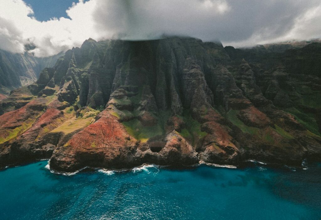
Puu O Kila Lookout sits at the very end of Kokee Road, roughly 4,176 feet above the Pacific, where the pavement stops and the Napali cliffs fall away into Kalalau Valley. It is the second and final vista along Route 550 past Kokee State Park, a short walk from a small paved lot at the road terminus.
The view is one of the most photographed in the Hawaiian chain, but it is also one of the most weather-dependent. Cloud cover rolls in from the windward flank most afternoons and can smother the valley within minutes, so households planning the drive from Poipu, Lihue, or Kapaa treat arrival timing as the single most important variable.
This guide covers the drive, the fee schedule, the Pihea Trail departure that shares the same parking lot, and the layered clothing that first-time visitors from the mainland routinely underestimate at elevation.
Where Puu O Kila Sits in Kokee
Kokee State Park spans roughly 4,345 acres of upland forest on Kauai’s western flank, and Puu O Kila caps the northern end of the paved road through it. Waimea Canyon State Park sits to the south and blends into Kokee without a hard boundary. The lookout is about 19 miles from the Route 50 turnoff in Waimea town.
The parking area is small — roughly 25 stalls on a good day — and it is the trailhead for Pihea, the ridge route that connects to the Alakai Swamp boardwalk. Two viewing platforms sit within a 100-yard walk of the lot, one paved and railed, the other reached by a short earthen path.
The View Into Kalalau Valley
Kalalau Valley opens roughly 3,000 feet below the lookout, a hanging amphitheater cut by streams over millions of years. From the platform, the ridges of the Napali Coast fan out toward the ocean roughly 4 miles distant. On the clearest days the Pacific horizon is visible where the valley mouth meets the sea.
The valley floor is closed to vehicle access; the only ways in are the 11-mile Kalalau Trail from Kee Beach or by permitted kayak. From Puu O Kila the settlement remnants below are invisible to the naked eye, but the terraces built by early Hawaiian farmers still shape the slopes on the valley’s east wall.
Ridge-to-ridge distances along the visible panorama run roughly 2 to 3 miles, giving the vista a sense of scale that photographs consistently fail to capture. A wide-angle lens or a stitched panorama tends to work better than a single frame from a phone.
What faces the viewer
Facing due north from the paved platform, the ridge to the left runs toward Kalalau Beach; the ridge to the right climbs toward the summit plateau. The lower slope directly ahead is called Kanakou. On overcast days the view resembles a wall of gray; on clear days the greens shift from moss to olive as the sun moves across the ridges.
Cloud Cover Timing and Morning Arrival
The Kokee summit ridge intercepts moisture pushed inland by the northeast trades, and clouds form on the windward side almost daily. National Weather Service climate summaries show Kokee averaging around 70 inches of annual rainfall — several times the rate on the Poipu coast 25 miles away.
Practical implication: reach Puu O Kila before 10 a.m. year-round, and closer to 8 a.m. between June and September when convective clouds build fastest. Late afternoon arrivals often meet solid whiteout, and evening rain can persist through the drive back down.
Winter visitors face a different tradeoff. Between December and March, front systems can pin cloud cover in place for entire days, but breaks between fronts often deliver the sharpest views of the year with fresh, low-humidity air scouring the valley.
| Month | Best arrival window | Typical afternoon cloud | Rain risk |
|---|---|---|---|
| January | 7:30–10:00 a.m. | High, front-driven | Moderate |
| April | 7:00–10:00 a.m. | Moderate | Low |
| July | 6:30–9:00 a.m. | Very high, convective | Low but sudden |
| October | 7:00–10:30 a.m. | Moderate | Low |
| December | 7:30–10:00 a.m. | High, sustained | Moderate to high |
Reading the clouds on the drive up
Drivers heading up Route 550 can gauge conditions by watching Waimea Canyon at Puu Hinahina and the earlier rim overlooks. If the canyon rim is clogged with cloud at 3,400 feet, Puu O Kila at 4,176 feet will almost certainly sit inside the cloud layer. The sequence of Waimea Canyon rim overlooks works well as an early warning system.
Households traveling with children sometimes reverse the itinerary: drive to Puu O Kila first while the summit is clear, then work back down through the canyon overlooks as afternoon clouds build. Conditions at the upper elevation deteriorate more quickly than at the mid-elevation rim.
Getting There — Driving Route 550
Route 550, sometimes signed as Waimea Canyon Drive and Kokee Road, is the only paved route into the park. It climbs from near sea level in Waimea town to 4,000 feet in roughly 19 miles, with a series of switchbacks in the first six miles that surprise drivers accustomed to interstate grades.
The Hawaii Department of Transportation classifies the road as fully paved with two lanes throughout, but shoulders are minimal and passing zones are rare. Average drive time from the Route 50 junction to Puu O Kila runs 45 to 55 minutes without stops. Check state road advisories before departure during storm season.
Starting mileage from common bases: Poipu is roughly 34 miles and 75 minutes; Lihue is 41 miles and 90 minutes; Kapaa is 48 miles and 105 minutes; Princeville is 66 miles and about 2 hours. Fuel up in Waimea or Kalaheo — no service stations exist above the town.
| Starting point | Distance to Puu O Kila | Drive time | Elevation gain |
|---|---|---|---|
| Poipu | 34 miles | 75 min | 4,000 ft |
| Lihue Airport | 41 miles | 90 min | 4,000 ft |
| Kalaheo | 28 miles | 60 min | 3,200 ft |
| Kapaa | 48 miles | 105 min | 4,000 ft |
| Princeville | 66 miles | 120 min | 4,000 ft |
Road hazards to expect
- Feral chickens and goats crossing the pavement, especially near mile 12
- Fog banks between mile 10 and the summit, often below 100 feet visibility
- Cyclists climbing at 6 to 8 mph in the shoulder-less switchbacks
- Occasional loose rock after heavy rain — check advisories first
- No cell service above mile 8 on most carriers
Kokee State Park Entry Fee and Parking
Kokee and Waimea Canyon State Parks share a single non-resident fee schedule administered by Hawaii’s Division of State Parks. Adults pay $5 per person and parking is $10 per vehicle. Kama’aina and military ID holders enter free with valid documentation. Fees are collected at the Waimea Canyon Lookout kiosk, not at Puu O Kila itself.
Payment methods include credit card and cash at staffed booths, and mobile pay through the state’s reservation portal. Households traveling in one vehicle pay a single $10 parking charge plus $5 per non-resident occupant. Keep the receipt visible on the dashboard through Puu O Kila and any downstream overlook stops.
The state does not require advance reservations for Kokee or Puu O Kila, unlike Haena State Park at the north end of the island. Weekend crowds still fill the Puu O Kila lot between 10 a.m. and 2 p.m., so early arrival avoids the frustration of circling for a stall.
| Fee item | Non-resident cost | Kama’aina cost | Collection point |
|---|---|---|---|
| Adult entry | $5 per person | Free with ID | Waimea Canyon kiosk |
| Parking | $10 per vehicle | Free with ID | Waimea Canyon kiosk |
| Camping (per site) | $30 per night | $18 per night | Online reservation |
| Cabin rental | $95+ per night | $95+ per night | Kokee Lodge |
Facilities at the lookout
Restrooms at Puu O Kila are vault-style and often locked outside daylight hours. There is no potable water at the lot; the nearest tap is at the Kokee Natural History Museum roughly 4 miles back down the road. Trash cans exist but overflow on weekends. The lodge at mile 15 serves food from 9 a.m. to 2:30 p.m. most days.
Pihea Trail Departure from the Same Lot
The Pihea Trail leaves directly from the north edge of the Puu O Kila parking area, marked by a wooden signboard. The initial half mile follows an unpaved former road grade along the Kalalau rim, offering repeated valley views and a gentler introduction than most Kokee footpaths deliver.
Beyond the Pihea Peak junction at 0.9 miles, the trail drops steeply on roots and mud before joining the Alakai Swamp Boardwalk. Total distance to the Kilohana Overlook at the far end runs roughly 3.7 miles one way, with 800 feet of elevation change. Detailed grade notes appear in the Alakai Swamp Boardwalk write-up.
Most visitors turn around at Pihea Peak or the boardwalk junction rather than pushing through to Kilohana. The peak spur adds 15 minutes and delivers a bird’s-eye of Kalalau from a higher angle than the paved lookout offers.
| Waypoint from lot | Distance | Elevation change | Typical time |
|---|---|---|---|
| First Kalalau overlook | 0.2 mi | Flat | 5 min |
| Pihea Peak junction | 0.9 mi | +180 ft | 25 min |
| Alakai Swamp junction | 1.75 mi | −400 ft | 55 min |
| Kilohana Overlook (turnaround) | 3.7 mi | +220 ft return | 2 hr each way |
What to bring for the trail
- Waterproof boots or trail runners — mud is constant past Pihea Peak
- 1 liter of water minimum, 2 liters for the full Kilohana push
- Layered clothing rated to 55°F
- Trekking poles for the root-covered descent to the boardwalk
- A dry bag or plastic sleeve for phones and cameras
Compare Pihea’s ridge terrain to the switchback trails inside Waimea Canyon proper, cataloged by tier in the Kokee State Park difficulty guide. Ridge hiking exposes walkers to weather more directly than the canyon options, and turnaround windows compress fast when a squall arrives.
Packing the Rain Jacket — What Elevation Demands
Kokee’s climate catches mainland visitors off guard. Where Poipu sits at 78°F and 20% humidity on a July afternoon, Puu O Kila can register 60°F with wind gusts pushing wind chill into the low 50s. A cotton hoodie soaks through in minutes when cloud drizzle sweeps the ridge.
A rain jacket rated to at least 10,000 mm hydrostatic head, with taped seams and a hood, keeps a family functional through unexpected weather. Pit zips help on the climb toward Pihea Peak, where exertion generates heat even in cool air. Ponchos work as backup but flap uncontrollably in ridge wind.
Households traveling from Waikiki or Kihei often skip warm layers entirely and buy fleeces at ABC Stores after the first cold morning. The math favors packing from the mainland: a lightweight fleece and shell together weigh under two pounds and cost half of resort-market replacements.
Rain jacket packing card
| Item | Specification | Approximate cost | Weight |
|---|---|---|---|
| Waterproof shell | 10,000+ mm HH, hood, pit zips | $80–$180 | 10–14 oz |
| Fleece mid-layer | 200-weight fleece or grid | $45–$90 | 10–16 oz |
| Beanie or ear band | Merino or synthetic | $15–$30 | 2 oz |
| Quick-dry pants | Nylon, roll-up cuffs | $50–$110 | 10 oz |
| Waterproof pack cover | 25L capacity | $18–$35 | 3 oz |
Health department guidance for high-elevation trails on Kauai emphasizes core-temperature management for young children and adults over 65. The Hawaii Department of Health notes that hypothermia can develop in as little as 30 minutes when clothing is soaked and wind exceeds 15 mph. Kokee routinely meets both conditions.
Layering strategy from the parking lot
- Base layer: quick-dry synthetic or merino T-shirt
- Mid layer: fleece or light insulated jacket
- Shell: waterproof, hooded, taped seams
- Bottom: quick-dry pants over lightweight base if temperatures drop
- Extremities: warm hat, thin gloves, wool-blend socks
The Rental Car Question
Every mainland household reaching Puu O Kila arrives by rental car; there is no bus service into Kokee State Park and no rideshare drivers venture up Route 550. The lookout is one of the strongest arguments on Kauai for renting a full-size sedan or small SUV rather than a subcompact.
Compact cars handle the switchbacks fine but struggle for luggage space when families combine the Puu O Kila drive with a beach day at Polihale or Kekaha on the same trip. Standard 4WD is not required — Route 550 is fully paved — but it helps confidence on wet, foggy descents.
Rental prices at Lihue Airport track national averages plus a Hawaii premium of roughly 20 to 30 percent during winter and summer peaks. Off-airport pickups in Poipu or Lihue town run cheaper but add a taxi or shuttle cost from the airport terminal.
Rental car card
| Vehicle class | Daily rate (shoulder) | Daily rate (peak) | Fits Kokee well? |
|---|---|---|---|
| Economy (Nissan Versa) | $52 | $95 | Yes for two adults |
| Compact SUV (Kona) | $68 | $115 | Yes for four |
| Mid-size SUV (RAV4) | $85 | $140 | Ideal for families |
| Jeep Wrangler 4WD | $115 | $210 | Overkill for paved road |
| Minivan (Odyssey) | $105 | $175 | Good for gear-heavy trips |
Fuel matters. Hawaii pump prices consistently sit among the highest in the nation, tracked weekly by the U.S. Energy Information Administration. Round-trip fuel from Lihue to Puu O Kila and back runs roughly $18 to $28 depending on vehicle class and current per-gallon price. Waimea town has the last reliable pumps before the climb.
Return the tank near-full at the airport ring or accept the fuel-service premium — often $9 to $12 per gallon. For late departures on other islands, planning parallels the Kahului red-eye return strategy, adjusted for Lihue’s smaller terminal and shorter shuttle loop.
Insurance and driver tips
- Decline duplicate CDW if a credit card already provides collision coverage
- Verify Hawaii driving is allowed on the card’s policy
- Photograph the rental at pickup and drop-off for damage disputes
- Add a second driver at booking — most agencies charge $15 per day at counter
- Keep the parking receipt from Kokee visible for the return inspection
Comparing Puu O Kila with Kalalau Lookout
Kalalau Lookout sits at mile 18 on Route 550, roughly 0.7 miles below Puu O Kila. It offers a similar view of the same valley from a slightly lower angle and often clears earlier when clouds are lifting. Many visitors pair both lookouts on the same morning because the marginal drive time is minimal.
The advantage of Puu O Kila is the Pihea trailhead and the more direct sight line down the valley floor. Kalalau Lookout, by contrast, has a larger parking area, restrooms that are usually open, and a slightly more forgiving overlook rail for children.
| Feature | Puu O Kila | Kalalau Lookout |
|---|---|---|
| Elevation | 4,176 ft | 4,000 ft |
| Parking stalls | ~25 | ~40 |
| Trailhead access | Pihea Trail | None on-site |
| Restrooms | Vault, often locked | Open daylight hours |
| Best time slot | 7:30–10:00 a.m. | 7:00–10:30 a.m. |
Related island vantages
Kauai holds several ridge and coastal viewpoints worth grouping into a single itinerary. The Kekaha sunset pullout pairs with a Puu O Kila morning to bookend the day, while the Wailua Falls turnout works for households approaching from the east side.
Households evaluating the south shore for base lodging often anchor at Poipu; the Shipwreck Cliff overlook shows the coastal ridge structure at ground level rather than from 4,000 feet. Comparable ridge-into-valley experiences exist on other islands as well, most notably at the Waipio Valley vantage on Hawaii Island.
Weather, Elevation, and Health Considerations
Puu O Kila’s elevation of 4,176 feet is not extreme by continental standards, but the combined effect of thin marine air, high humidity, and rapid weather shifts creates conditions that catch some visitors flat-footed. Nausea and headache from mild altitude adjustment are uncommon but not unheard of, especially after an early-morning drive from sea level.
Ambient temperatures at the summit run 20°F cooler than Poipu Beach in most seasons. July highs at the lookout typically stay in the mid 60s; December mornings can drop into the mid 40s with wind chill in the upper 30s. Sunglasses matter even on cloudy days — UV exposure remains high through thin overcast.
Visitors with respiratory conditions should note that vog from the Big Island volcanoes can drift over Kauai during south wind episodes, degrading air quality even at Kokee. The state air quality monitoring system reports conditions in near-real time.
Sunrise and sunset timing
| Month | Sunrise at lookout | Sunset at lookout | Golden hour length |
|---|---|---|---|
| January | 7:10 a.m. | 6:03 p.m. | 45 min |
| April | 6:20 a.m. | 6:52 p.m. | 35 min |
| July | 5:52 a.m. | 7:15 p.m. | 30 min |
| October | 6:15 a.m. | 6:15 p.m. | 35 min |
Native birds and forest character
The Ohia lehua forest at Kokee shelters some of Kauai’s last populations of native honeycreepers, including the crimson Iiwi and Apapane. Bird activity peaks in the first two hours after sunrise, one more argument for early arrival. Rapid Ohia Death has been tracked across the state and visitors are asked to brush boot soles before entering trails.
Endemic tree cover thins near the ridge itself but expands quickly along Pihea. State forestry rules prohibit collecting plants, seeds, or feathers from any point in the park. Federal Census figures for Hawaii County are cataloged at census.gov quickfacts for broader demographic context on the surrounding islands.
History and Cultural Context of Kalalau Valley
Kalalau Valley was continuously inhabited by Native Hawaiian communities into the late 1800s. Terraced kalo fields still visible on the valley walls fed several hundred residents at peak population. The last permanent residents departed by the 1920s, though remnants of stone walls and heiau sit below the sightline from Puu O Kila.
The valley’s isolation preserved a distinctive way of life that historians still study. Ongoing debates about backcountry permitting, illegal camping, and enforcement in the valley below appear regularly in local coverage. Reporting from the Honolulu Civil Beat archive gives current policy context for households researching the area.
State officials note that valley access rules exist for both cultural preservation and safety reasons. Puu O Kila remains the safest and most family-friendly way for visitors to see Kalalau, and the lookout carries no permit requirement or advance reservation system.
Photography Notes for Puu O Kila
Golden hour hits the Napali ridges from the east, so morning light rakes across the valley floor and picks out ridge textures that flat midday sun washes out. Photographers targeting the peak lighting window aim for arrival 15 to 20 minutes before sunrise in summer, or right at sunrise in winter when clouds are less aggressive.
A wide-angle lens between 16mm and 24mm on a full-frame body captures the panorama without distortion. Phone cameras handle the scene reasonably at ultra-wide settings but struggle with contrast when clouds partially cover the ridges. Bracketed exposures merged in HDR software produce the most consistent results in mixed lighting.
Drone use is prohibited inside Kokee State Park boundaries under state park rules. Rangers enforce the ban and issue citations. A tripod helps for low-light morning shots — the wind at 4,000 feet can push handheld exposures beyond usable shutter speeds even with image stabilization active.
Trip Planning: Combining Puu O Kila with a Full Kauai Day
The drive up and back consumes roughly 3 hours of windshield time from most bases, plus 45 to 90 minutes at the lookouts themselves. Households can extend the day with a Kokee Lodge lunch stop, a Waimea Canyon rim overlook loop, or a swim at Salt Pond Beach on the return.
For longer stays, some visitors research settling in the upcountry belt above Poipu; the relocation profile of Kalaheo covers the tradeoffs of living at 800 feet elevation with easy access to both the Kokee road and south-shore beaches. Kalaheo residents can reach Puu O Kila in under an hour without hitting Poipu-Lihue traffic.
Families staying near Princeville should consider whether the four-hour round trip is worth pairing with the Kalalau Trail on a separate day rather than trying to combine both. Weather at the two endpoints is independent, and doubling the drive doubles the risk of a fogged-out arrival.
Sample morning itinerary from Poipu
- 5:30 a.m. — Depart Poipu, fill fuel in Kalaheo or Waimea
- 7:00 a.m. — Pass Waimea Canyon kiosk, pay entry fee
- 7:30 a.m. — First stop at Waimea Canyon Lookout
- 8:15 a.m. — Arrive Puu O Kila for clear valley view
- 9:15 a.m. — Walk out to Pihea Peak (optional add-on)
- 11:30 a.m. — Lunch at Kokee Lodge
- 1:30 p.m. — Return to Poipu via Route 550 and Route 50
Frequently asked questions
Is Puu O Kila Lookout free to visit?
The lookout itself is free once inside Kokee State Park, but non-residents pay a $5 per-person entry fee and $10 per-vehicle parking charge collected at the Waimea Canyon kiosk lower on the road. Kama’aina residents and active military enter free with valid identification. Fees are set by Hawaii’s Division of State Parks and change occasionally, so verify current rates before departure.
How long is the walk from the parking lot to the viewpoint?
The main paved overlook sits roughly 100 yards from the Puu O Kila parking lot along a short concrete path. A second, higher earthen vantage adds another 50 yards and about 20 feet of gentle climb. Both are wheelchair-accessible in dry conditions, though the earthen path becomes slick after rain and is best skipped in wet weather.
What is the best time of day to arrive for clear views?
Aim to reach Puu O Kila between 7:30 and 10:00 a.m. in most months. Clouds typically build over the Napali ridges by late morning and can shroud the valley completely by early afternoon. Summer visitors should target 6:30 to 9:00 a.m. because convective clouds form fastest. Winter fronts can pin cloud cover in place for entire days.
Can visitors hike into Kalalau Valley from the lookout?
No — there is no legal trail from Puu O Kila down into Kalalau Valley itself. The only ground access is the 11-mile Kalalau Trail from Kee Beach on the north shore, which requires a state camping permit for overnight travel. From Puu O Kila the valley is a viewing experience only, not a hiking-access point for the floor.
How cold does it get at Puu O Kila?
Summer highs typically reach the mid 60s Fahrenheit with early-morning lows near 55°F. Winter mornings can drop into the mid 40s and wind chill can push effective temperature into the upper 30s. Cloud drizzle is common year-round. A waterproof shell and a fleece mid-layer are essential rather than optional for anyone arriving before mid-morning.
Is a four-wheel-drive rental needed?
No four-wheel-drive is needed to reach Puu O Kila. Route 550 is fully paved from Waimea town to the parking lot at the road terminus. A compact sedan handles the switchbacks fine. Confidence in wet, foggy descents comes more from careful speed than from drivetrain — 4WD does not shorten stopping distance on wet asphalt.
Are there restrooms and water at the lookout?
Vault-style restrooms exist at the Puu O Kila lot but are frequently locked outside daylight hours. No potable water is available on-site. The nearest reliable restroom and water tap is at the Kokee Natural History Museum about four miles back down Route 550. Kokee Lodge nearby serves food and drinks from 9 a.m. to 2:30 p.m. most days.


