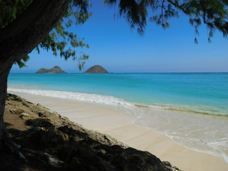
The pair of small islets off Kailua’s Lanikai coast — known as the Mokulua Islands or simply “the Mokes” — sits about 1.25 miles offshore, close enough to see clearly from the beach and far enough to demand a considered plan. Moku Nui, the larger of the twins, is the only islet where landings are legally permitted, and even that access is restricted to a specific sandy stretch on its west side facing Kailua.
Moku Iki, the smaller sibling to the south, remains a strict seabird sanctuary closed to all foot traffic under state law. The channel between the two islets funnels current and wind chop, so most confident paddlers plan launches for the early trade-wind window before 10 a.m. when the surface tends to lay flatter and the return leg stays manageable.
The full round trip typically consumes 3–4 hours including a beach break, and rentals from Kailua-based permitted outfitters run roughly $59–$89 per single kayak for a full day. This research brief covers the paddle route, DLNR sanctuary rules, tidepool constraints on the back side of Moku Nui, wind reading, safety gear, and the practical logistics households consider when adding a Mokulua day to a longer O’ahu research stay.
The Lanikai and Kailua Beach launch geography
Two beaches serve as launching points for the Mokulua paddle. Lanikai Beach itself sits directly across from the islets, but the neighborhood has no public parking within reasonable walking distance of the sand-access easements. Most paddlers instead launch from Kailua Beach Park or the north end of Kailua Beach, then ride the trade-wind push south along the shoreline before angling east toward the islets.
Kailua Beach Park has restrooms, showers, and a paved parking lot that fills before 9 a.m. on weekends. Overflow parking spreads through the surrounding residential streets, though signage prohibits stopping in several enforcement zones. The launch line-up on a fair-weather Saturday can include 40–60 kayaks, stand-up paddleboards, and outrigger canoes staging together on the sand.
Access from Waikiki and windward transit times
Kailua sits roughly 12 miles from Waikiki via the Pali Highway or 15 miles via the H-1/H-3 route. Morning drive times run 25–35 minutes from Waikiki, 20 minutes from downtown Honolulu, and 45–60 minutes from Ko Olina on the leeward side. TheBus route 67 connects downtown Honolulu to Kailua, but hauling kayak gear on public transit is impractical, so most visiting paddlers rent from Kailua-side shops that supply everything on site.
Parking constraints and the Lanikai residential context
Lanikai itself is a purely residential enclave of narrow streets and single-family lots along Aalapapa and Mokulua Drives. Overnight parking, oversized vehicles, and beach-access blocking are actively enforced by the City and County of Honolulu, per honolulu.gov guidance. Renting a kayak in Lanikai proper is nearly impossible; permitted outfitters instead cluster in the Kailua town business district roughly a mile inland from the beach.
The 1.25-mile crossing and route
From the Kailua Beach north end, the paddle stretch to Moku Nui measures about 1.4–1.6 miles depending on the exact launch point. From Lanikai’s south end, it drops closer to 1.1–1.25 miles as a direct crossing. Average paddling speed for an intermediate recreational paddler in a stable sit-on-top tandem runs 2.5–3 knots, translating to a one-way crossing of 25–35 minutes in benign morning conditions.
Wind acceleration between the islets and the shore is the defining variable. Standard northeast trades of 10–18 mph funnel through the channel and stack short-period wind chop of 1–3 feet across the paddler’s beam on the return leg. Afternoon returns against building trades can double the crossing time and exhaust paddlers who launched at 10 or 11 a.m. rather than a first-light start.
Paddle sequence for a typical morning
A conservative Mokulua paddle sequence unfolds as follows:
- Arrive at Kailua Beach Park between 7:00 and 8:00 a.m.
- Rig kayaks, receive rental briefing, and launch by 8:30 a.m.
- Cross to Moku Nui’s west beach in 25–40 minutes.
- Spend 60–90 minutes on the sandy west beach section.
- Depart Moku Nui by 10:30 a.m. for the return leg.
- Return to Kailua Beach before trades peak at noon.
- Off the water and rinsed by 11:30 a.m.
Reading whitecaps and channel chop
Whitecaps visible from Lanikai’s south end are a decision point. A whitecap band across the channel typically means winds have crossed 15 knots, which pushes crossing times from 30 minutes to 50–70 minutes on the return. Local outfitters use a “no whitecaps by 9 a.m.” heuristic when advising unguided renters whether the day is a paddle day or a shore day.
Tide range around O’ahu is modest, cycling roughly 0.8–2.2 feet between low and high across a mixed semidiurnal pattern. Tide has little effect on the crossing itself, but the sand berm at Moku Nui’s landing beach can shrink to a narrow strip at high tide, complicating group staging on busy Saturdays with multiple guided tours ashore at the same time.
DLNR seabird sanctuary status and legal landing rules
Both Mokulua islets are designated as State Seabird Sanctuaries under the Hawaii Department of Land and Natural Resources’ Division of Forestry and Wildlife. The designation protects breeding populations of wedge-tailed shearwaters, Bulwer’s petrels, and red-footed boobies that nest in burrows in the low vegetation on the interior slopes of each islet.
Moku Iki — the southern islet — is fully closed to all landings, foot traffic, and shoreline access, year-round. There is no lawful way to step onto Moku Iki, including for photography, snorkel exits, or emergency stops except in life-threatening situations. Fines for unauthorized landings can reach several hundred dollars per violation under DLNR enforcement authority applied to the sanctuary boundary.
Wedge-tailed shearwater burrows and nesting seasons
Wedge-tailed shearwaters (Ardenna pacifica) nest from March through November on both islets, digging shallow soil burrows on the vegetated slopes. Chicks fledge in late fall. Foot traffic outside the permitted beach zone collapses burrows and crushes chicks, a documented issue that drove tightened enforcement. Similar habitat-integrity concerns underlie the broader Hawaii shoreline setback framework governing state coastal access.
Moku Nui: the sandy west beach only
On Moku Nui — the larger northern islet — landings are permitted only on the sandy west-facing beach that fronts Kailua. Foot traffic beyond that beach onto the interior, up the volcanic slopes, or around the shoreline to the back-side tidepool is not allowed. The DLNR posts signage at the beach line marking the permitted zone, and rangers do periodic enforcement visits during peak paddling season from April through October.
The permitted beach is roughly 200 feet long and 30–60 feet deep at low tide, with a gentle sand bottom that suits swim entries and picnic staging. Overview materials from the state land agency and the gohawaii.com tourism authority reinforce that this beach is the sole legal foot-access point on either islet, a rule shared across all published state channels.
Permitted outfitters, rentals, and the self-guided rule
The state of Hawaii and the City and County of Honolulu regulate commercial kayak operators through a permitting process managed via the Department of Land and Natural Resources. Only permitted outfitters can legally guide or land groups on Moku Nui, and the number of permits is capped. Rental-only shops can still rent to self-guided paddlers, but renters bear responsibility for compliance with all landing rules.
Rental rates across Kailua’s kayak shops trend within a narrow band. A single sit-on-top runs $45–$75 for a half day and $59–$89 for a full day. Tandems cost $65–$99 half day and $85–$129 full day. Most rentals include a paddle, PFD, seatback, dry bag, and beach cart for portage from the parking lot to the launch line at Kailua Beach Park.
| Rental type | Half day | Full day | Includes |
|---|---|---|---|
| Single sit-on-top | $45–$75 | $59–$89 | Paddle, PFD, cart |
| Tandem sit-on-top | $65–$99 | $85–$129 | Two paddles, two PFDs, cart |
| Guided Mokulua tour | $149–$189 | Included | Guide, snack, snorkel gear |
| SUP board | $39–$59 | $49–$79 | Paddle, leash, PFD belt |
Beach-cart portage and residential street rules
Kailua and Lanikai enforce a beach-cart rule requiring wheeled portage of kayaks from the rental shop or parking area to the sand. Dragging boats along asphalt or through the residential Lanikai lanes draws citations. Rental shops issue carts as part of the package, and permitted outfitters route their group loads through Kailua Beach Park’s parking area to minimize neighborhood disturbance on morning launches.
Guided tour vs self-guided rental math
Two adults comparing a $170 tandem full-day rental against a $189 per-person guided tour ($378 for two) face a $208 delta. The guided package covers rules briefing, on-water instruction, snorkel gear, snacks, and a fixed route. Self-guided paddlers save the delta but must interpret weather, enforce their own timing, and manage the return leg without professional support if conditions deteriorate.
Wind windows, tide, and swell reading
The dominant windward-side pattern is northeast trade winds that build through the morning and peak between noon and 3 p.m. The National Weather Service Honolulu office issues daily marine forecasts covering Kailua Bay conditions, and sustained wind above 20 mph is the informal threshold at which most Kailua outfitters begin restricting rentals or cancelling guided tours entirely for the day.
The best paddle windows fall between 7:00 a.m. and 10:00 a.m. year-round. In winter — roughly November through March — kona wind reversals occasionally bring south-facing swell and softer trades, opening afternoon windows but sometimes closing the launch beach entirely to safe surf entry. Summer high pressure ridges the trades hardest, making 6:30 a.m. launches routine for experienced local paddlers.
Seasonal patterns and kona reversals
A kona wind — a southwesterly reversal of the normal trade pattern — occurs several times each winter and shifts the wind against a paddler’s return line from Moku Nui. Kona conditions also often bring rain squalls, reduced visibility, and short-period south swell that can break inside the reef at Kailua Beach Park itself. Rental shops close during confirmed kona events until conditions stabilize.
The Queen’s Bath tidepool on Moku Nui
The back side of Moku Nui — meaning the eastern, ocean-facing edge — features a lava-rock tidepool that visiting bloggers and social feeds have popularized under the name “Queen’s Bath.” Unlike the well-known feature at Princeville on Kauai, this Mokulua pool sits behind a vegetated ridge and requires a shoreline scramble around a sea cliff exposed to open Pacific swell year-round.
The DLNR position is unambiguous: the shoreline scramble crosses the closed portion of the seabird sanctuary. Foot traffic beyond the permitted west beach violates the landing rules regardless of whether the pool is empty or crowded. The sea cliff route has also claimed lives from rogue-wave sweeps in recent years, most notably during winter north-swell events reported in Honolulu Star-Advertiser coverage.
Why the shoreline scramble is a closed-swim feature
Local rescue agencies including the Honolulu Ocean Safety and Lifeguard Services Division actively discourage visits to the back-side pool. There is no lifeguard, no cell reception at the pool level, and no straightforward evacuation path if a swimmer is injured. Winter surf averaging 6–14 feet on the outer face regularly overtops the pool rim and drags shoreline features into the open ocean, per Hawaii News Now incident reporting.
The Kauai Queen’s Bath comparison
A conservative research position for households planning a Mokulua paddle: enjoy the sand beach, swim in the sheltered lee, and skip the back-side pool. The Kauai Queen’s Bath at Princeville offers a comparable lava-pool experience with clearer state guidance and a defined descent trail, though it too closes seasonally when winter surf exceeds published thresholds along the north shore of Kauai.
Snorkeling and marine life on the crossing
The channel between Kailua and the Mokuluas covers a mix of sand flats, reef patches, and occasional turtle cleaning stations. Green sea turtles (honu) are frequently sighted, along with parrotfish, saddle wrasse, and the occasional spinner dolphin pod cruising through in the morning. Snorkel gear is optional but rewards paddlers who anchor briefly over the mid-channel reef line halfway across.
Reef strikes remain a real risk on the return leg, when tired paddlers cut inside the reef line and shallow up over coral heads. State guidance from the Hawaii Department of Health and DLNR treats coral contact as a habitat violation, and fin damage from paddle strikes accumulates over successive paddle-tourism seasons. Rental outfitters brief renters on reef-avoidance lines before launch.
Cost breakdown and day budget
| Line item | Cost per adult | Notes |
|---|---|---|
| Tandem kayak rental (half day) | $40 (split of $80) | Two-person tandem, includes gear |
| Waikiki-to-Kailua ride share round trip | $60–$90 | Via Pali Highway |
| Reef-safe sunscreen tube | $14–$22 | Zinc or non-nano titanium |
| Beach picnic lunch | $12–$18 | Kalapawai Market pickup |
| Water bottle and hydration | $4–$8 | 2 liters per adult minimum |
| Rental car half day (alternative) | $45–$65 | Waikiki pickup, self-drive |
A two-adult day trip from Waikiki lands between $170 and $260 for the paddle itself, food, sunscreen, and either ride share or rental car transit. Households making Mokulua one of several ocean days across a weeklong stay generally amortize a rental car across all activity days and prep meals at their lodging rather than paying $12–$18 per takeout lunch at Kalapawai or Whole Foods Kailua.
Kailua Beach Park amenities and post-paddle logistics
Kailua Beach Park has outdoor showers, restrooms, picnic tables, and shaded ironwood grove sections that make it a comfortable staging area for gear rinse and lunch. Coin-op paid parking does not exist; the lot is free and first-come. On Saturdays and Sundays the lot fills by 8:30 a.m., and returning paddlers who launched at 7:30 a.m. often find their car surrounded by later arrivals looking for a slot.
Safety gear and emergency planning
Coast Guard rules require a wearable PFD for each person on a kayak in Hawaii state waters. Rental shops supply Type III PFDs standard, and outfitters brief renters on actually wearing the vest during the crossing rather than clipping it to the seat. Additional recommended gear includes a whistle attached to the PFD, a waterproof phone pouch, a signal mirror in a dry bag, and 2 liters of water per adult.
Cell coverage across the Kailua Bay channel is generally strong on Verizon and AT&T, weaker on smaller carriers. Both islets sit within line-of-sight of Kailua-area cell towers, and 911 calls from the Moku Nui landing beach have completed reliably in reported incidents. Phones die and dry bags fail, so a whistle and a paddle-signal plan matter as backup regardless of carrier coverage.
Rescue coverage and response times
Honolulu Ocean Safety operates lifeguard towers along Kailua Beach with jet-ski rescue capacity. Response time from a tower to the mid-channel runs roughly 5–8 minutes on flat water, longer in wind chop. In-water incidents at Moku Nui itself trigger longer responses, sometimes requiring Coast Guard coordination from Marine Corps Base Hawaii on the north end of Kailua Bay.
Comparing Mokulua to O’ahu and neighbor-island paddles
| Paddle destination | Distance one way | Landing rule | Wind window |
|---|---|---|---|
| Mokulua Islands (O’ahu) | 1.1–1.6 miles | Moku Nui west beach only | Before 10 a.m. |
| Mokoli’i / Chinaman’s Hat (O’ahu) | 0.4 miles | Shore access with tide | Before 10 a.m. |
| Wailua River (Kauai) | 2 miles upriver | Fern Grotto trailhead | All day |
| Makena Landing (Maui) | 0.5–1.5 miles reef | Beach put-in only | Before 11 a.m. |
Compared with the shorter Mokoli’i crossing from Kualoa on O’ahu’s northeast coast, the Mokulua paddle triples the open-water exposure but rewards the effort with a defined landing beach and a designated sanctuary experience. The Wailua River route on Kauai offers protected fresh water and no wind exposure, making it a family-friendly alternative when trades blow out the Kailua option.
Maui’s Makena Landing supports shorter reef paddles with reliable turtle sightings, and Kauai’s Salt Pond ring is a quieter option for households who want ocean water without an open-channel crossing. The Mokulua paddle stands apart as a defined 1.25-mile round trip to a specific sanctuary beach with legally enforced landing constraints.
Trip planning: when to add Mokulua to a research trip
Households conducting a rent-first research trip to O’ahu typically slot Mokulua as a mid-week activity when Kailua parking loosens. Weekday paddles between Tuesday and Thursday see 40–60 percent less kayak traffic than weekends, and the sanctuary beach on Moku Nui shifts from crowded to relaxed. Long-term residency researchers often pair a Mokulua morning with a Lanikai neighborhood housing tour later in the same day.
The best-weather months for the paddle run roughly April through October, when trades stay in the 10–18 mph band and rain squalls are less frequent. Winter months bring more variable conditions with occasional kona wind days that reverse the direction of the paddle challenge and can close the launch beach entirely to safe entry from the reef side.
Sample weekly integration for relocating households
A typical seven-day O’ahu research week that folds Mokulua into a housing hunt:
- Day 1: Waikiki arrival, jet-lag recovery, sunset beach walk.
- Day 2: Manoa neighborhood tour and coffee-shop research.
- Day 3: Kailua and Lanikai housing scouting during business hours.
- Day 4: Mokulua paddle at sunrise from Kailua Beach Park.
- Day 5: North Shore drive with property viewings in Hale’iwa.
- Day 6: Downtown Honolulu work session and DMV or tax office visit.
- Day 7: Departure with a morning Diamond Head hike.
Legal and regulatory backdrop
The Mokulua landing rules sit within a broader Hawaii coastal regulatory framework governing shoreline access, marine sanctuaries, and short-term commercial ocean operations. State agencies including DLNR, the Department of Health, and the Department of Transportation each hold jurisdiction over different aspects of the paddle experience — from vessel registration to water quality reporting to harbor permitting.
Honolulu-side commercial ocean tour operators must hold both a state Commercial Ocean Recreation Operator (CORO) permit and City and County business registration to guide Mokulua trips. Guided tour rates run higher — $149–$189 per person for a half-day trip — because the CORO permit fee, insurance costs, and boat-count caps flow through to consumer pricing. Adjacent regulations shape the state’s DOBOR harbor and mooring permit process for private craft.
Cultural context and Hawaiian names
The name “Mokulua” translates roughly as “two islands” in Hawaiian — moku (island) and lua (two). Moku Nui means “large island” and Moku Iki means “small island.” The islets are geologically volcanic remnants associated with the Ko’olau Range, and pre-contact Hawaiian communities on the windward side used the surrounding waters for fishing rather than for regular landings on the islet slopes themselves.
Because both islets are seabird sanctuaries and Moku Iki is fully closed, the modern paddle culture on the Mokes has settled into a narrow set of accepted activities: the crossing itself, the west-beach picnic, a casual swim in the sheltered lee, and the return. That narrow scope is the point — sanctuary protection is what preserves the experience for future paddlers to enjoy.
Frequently asked questions
Can visitors land on Moku Iki?
No. Moku Iki is a fully closed State Seabird Sanctuary under DLNR jurisdiction. No landings, no shoreline foot traffic, and no picnicking are permitted at any time of year. Only Moku Nui — the larger northern islet — allows landings, and even those are restricted to a specific 200-foot sandy west-facing beach section marked by DLNR signage at the beach line.
What is the best time of day to launch?
Between 7:00 and 9:00 a.m. year-round. Trade winds typically stay under 15 mph in that window, and the crossing runs 25–40 minutes each way. Launching later than 10 a.m. often means returning against 15–20 mph trades and 2–3 foot wind chop, doubling the return leg time and exhausting paddlers who underestimated the afternoon build.
Do renters need a permit or license?
Individual recreational paddlers do not need a permit to rent a kayak or land on Moku Nui’s permitted beach. Only commercial guides carrying paying customers require the state Commercial Ocean Recreation Operator permit. Self-guided renters bear personal responsibility for compliance with landing rules, seabird sanctuary boundaries, and Coast Guard PFD requirements during the crossing itself.
How rough is the crossing for a first-time kayaker?
The morning crossing under 12 mph trades suits a novice paddler in a stable sit-on-top tandem. Beyond 15 mph or with any south swell, the channel produces a beam-chop pattern that challenges balance and steering. Rental shops brief renters on conditions before launch and refuse rentals when marine forecasts exceed the operator’s own safety threshold for the day.
Is the Queen’s Bath tidepool safe to visit?
The pool sits on Moku Nui’s back side beyond the permitted landing zone, so reaching it violates DLNR sanctuary rules. It also carries genuine safety risk from rogue-wave sweeps that have caused fatalities in recent years. Local rescue agencies discourage the visit. Research-first households skip the pool and stay on the permitted west beach for the sanctioned experience.
What happens if a paddler gets stranded on Moku Iki?
Emergency contact by phone or whistle triggers Honolulu Ocean Safety and Coast Guard response. Rescuers may land regardless of the sanctuary closure to remove a stranded party, but the underlying landing violation still applies and can trigger enforcement action after the fact. Preventive planning — checking wind forecasts and reserving energy for the return — avoids the scenario entirely.
Does the Mokulua paddle require prior kayak experience?
No formal experience is required, but comfortable swimming ability, familiarity with sit-on-top paddling, and willingness to wear a PFD throughout the crossing all matter. Rental shops brief novices on stroke technique and self-rescue re-entry before launch. Households with young children under age 8 typically choose the guided-tour option rather than a self-guided rental.